Skip to content

Or try searching by Category and/or Location

Ring road sights

Travelling the Ring Road of Iceland is an experience that many seek to enjoy. Along the road, travellers can find multiple natural highlights as well as accommodation and food. It's not necessary to wander too far from the road in order to enjoy these highlights although we highly recommend going off the beaten track and drive along the Arctic Coast Way or the Diamond Circle for a very different road trip.

Kolugjúfur
 As you drive along Víðidalur, you will come to Kolugil Farm which stands beside the Víðidalsá river. Just below the farm, the waters flow peacefully downwards to plunge into the deep, rugged gorge called Kolugljúfur. Their journey then sends them cascading over many waterfalls which bear the name Kolufossar Falls in honour of the giantess, Kola. It is a breathtaking sight to walk on the the viewing platform and watch the calm waters of the river suddenly leap and tumble onwards over so many impressive falls – a sight which will leave no one unmoved.
Borgarvirki
Borgarvirki is a 10-15 metre high ridge of columnar rock. This phenomenon is a volcanic plug, and there is speculation as to whether it was, in ancient times, a district fortress and even, perhaps, a battleground.From Borgarvirki there is a wide panoramic view over a large part of the region and a viewfinder is in place to help locate some of the important landmarks.This is truly a unique natural phenomenon, but one which has also seen some improvements by the hand of man in bygone days.
Vatnsdalshólar
Vatnsdalshólar are a cluster of hills of all sizes across the mouth of Vatnsdalur valley. Thought to have been formed by a catastrophic landslide. These hills are considered to be one of the three “innumerables” things in Iceland along with the lakes in Arnarvatnsheidi and the islands on Breidarfjord in the west.
Þingeyrakirkja church
Þingeyrar was, in past times, one of the most famous estates in Húnaþing and also the site of a church. Now, the Þingeyrakirkja church commands one of the widest and most beautiful panoramic views in the county. It is said that no estate was as big as or endowed with such elegant buildings as Þingeyrar, which is probably not surprising as it was home to chieftains and the elite for many centuries. Þingeyrakirkja church was built of stone and consecrated in 1877. Þingeyrar was also the site of the Iceland’s first monastery, founded in 1133.
Hrútey
  Hrútey Island is the real feather in the cap of Blönduós town, which is almost encircled by the river Blanda. Hrútey is blessed with a wide variety of vegetation and birdlife is abundant, being the habitat of geese and many other species. It is easily accessible and lies just off Highway 1. There is a good parking area by the river bank and a trusty pedestrian bridge over to the island. Hrútey is an excellent place for outdoor exercise, or just to stop and take a break. There are good footpaths and a clearing with benches and picnic tables.
Víðimýrarkirkja church
Víðimýrarkirkja church is one of the few preserved turf churches in Iceland.  At the beginning of the 20th century its fate was uncertain, but luckily the immense cultural value of the building was recognised in time, and the National Museum of Iceland became responsible for its renovation. The church was built in 1834 and has turf walls, but timber gables both back and front.
The Pond
The Pond in Akureyri is a fun outdoor recreation area in the heart of the town. In summer, it is buzzing with life when cruise ships start coming with guests from all over the world as well as small boats are fishing and sailing around. At the Pond, there is a variety of birdlife, the whales blow, and occasional seals can be seen.
Akureyri Church
The Akureyri church is the symbol of Akureyri. It is a Lutheran church and was designed by the famous architect Gudjon Samuelsson and consecrated in 1940. The central stained-glass window above the altar formed apart of a set originating from England. The bas-reliefs on the nave balcony are by sculptor Asmundur Sveinsson and the baptismal font is a replica of a work by sculptor Bertel Thorvaldsen.  The church is above the town center.  Attention!Please note that the church is closedwhen funerals or other services are taking place and it is advertisedespecially on the church door. For more information check the website akureyrarkirkja.is or send an email at akirkja@akirkja.is. 
Akureyri Botanical Garden
Akureyri Botanical Garden (Lystigarður Akureyrar) is one of the northernmost botanical gardens in the world and a peaceful green oasis in the heart of Akureyri. Established as a public park in 1912, with the botanical garden added in 1957, it has grown into one of the town’s most beloved attractions. 
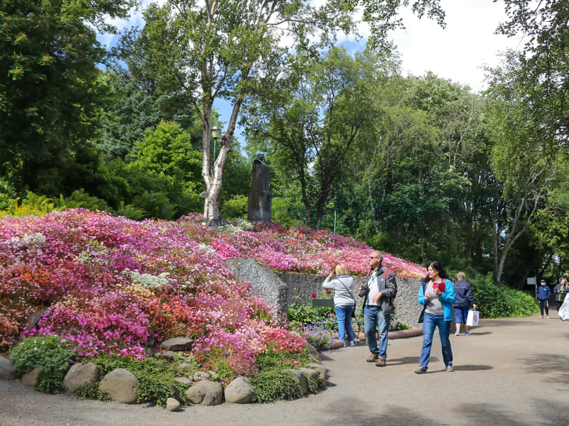
The garden was founded through the initiative of local women, led by Anna Schiöth, whose vision helped create one of Akureyri’s most cherished public spaces. Her daughter-in-law, Margarethe Schiöth, continued the work and played a key role in the development of the garden. A bust of Margarethe stands within the grounds, bearing the inscription: “She made the garden famous.” Located on the slopes above the town centre, the garden enjoys a favourable microclimate created by Eyjafjörður, allowing an impressive variety of plants to thrive despite its northern location. Alongside Iceland’s native flora, thousands of plant species from around the world can be found throughout the garden, creating a colourful display from spring to autumn. Visitors can stroll along winding paths, enjoy the diverse plant collections and experience a tranquil setting just a short walk from the centre of Akureyri. The garden also plays an important role in plant conservation, education and international seed exchange. The Botanical Garden is open daily during the summer season, while the grounds remain accessible year-round for those wishing to enjoy a walk through the park. 
Mountain Súlur
Mt. Súlur is the town mountain of Akureyri. 
Goðafoss waterfall
The Goðafoss waterfall is one of the most spectacular waterfalls in Iceland. The water of the river Skjálfandafljót falls from a height of 12 meters over a width of 30 meters. The ring road goes past the waterfall, with parking available on both sides of the river and paved walking paths to viewing platforms. The history of the waterfall is connected to the conversion of Icelanders to Christianity. Þorgeir Ljósvetningagoði, the country's law speaker, decided that the official religion of the country should be Christianity as pressure grew from other European countries with Norwegians at the forefront. The original Icelandic settlers were mostly Norwegians, and in order to keep the peace, Þorgeir took the decision of conversion.  Afterwards, he threw his idols of the Old Norse religion gods into the waterfall. The Icelandic word for gods is goð, and so the waterfall has been called Goðafoss ever since.Goðafoss is part of the Diamond Circle.  https://www.northiceland.is/diamondcircle  
Lake Mývatn
Mývatn is the 4th largest lake in Iceland, 37 km2 in area. Its shores are indented with many coves and inlets and its surface is dotted with around 50 small islets and skerries. Midges (Chironomidae) are abundant and the ubiquitous swarms of these tiny flies give the Lake its name.The lake itself is very shallow, and the rays of the sun reach the lake bed over its entire surface. The ecology of the lake area is extremely diverse and interesting; one important characteristic of Mývatn, being the prolific growth and abundance of freshwater seaweed. On the bed of the lake are great quantities of diatoms, while, nearer the surface, Mývatn’s famous arctic char weave their way between aquatic plants and little islets topped with fertile vegetation. On and around the lake there is a teeming and varied birdlife, and Mývatn is the habitat of many kinds of lake and marsh birds. However, much of Mývatn’s fame is due to the fact that, during summer, there are more different species of duck gathered on and around the lake than anywhere else in the world. Mývatn is a legally protected conservation area and appears on the register of internationally important wetlands, along with the Laxá river which flows out of the lake.
Dimmuborgir
Dimmuborgir, often referred to as the “Dark Castles” or “Dark Cities”, is one of the most distinctive lava formations in Iceland. Located in the Mývatn region, the area is characterised by dramatic lava pillars, caves, arches and unusual rock formations created by a volcanic eruption thousands of years ago. A network of walking trails winds through this fascinating landscape, where visitors can explore natural lava structures of all shapes and sizes. Among the best-known formations is Kirkjan (“The Church”), a striking lava cave named for its high arching ceiling and cathedral-like appearance. Dimmuborgir has long been associated with Icelandic folklore and is said to be the home of the Icelandic Yule Lads.  The area can be explored year-round, with each season offering a different perspective on its remarkable lava formations and unique landscape. 
Grjótagjá
Grjótagjá is a small cave in the Lake Mývatn area, and was a popular bathing place at one time. However, geological activity in the period 1975-1984, caused the temperature of the water to rise to such a degree that it has not been possible to bathe there since. But one can always dream ... a peep into the waters and a fertile imagination can conjure up visions of taking a dip in this cosy little cave, as was the custom in the past.
Hverfjall
Hverfjall is a large circular explosion crater in the Mývatn region, approximately 140 metres deep and 1,000 metres in diameter. Formed during a volcanic eruption around 2,800–2,900 years ago, it is one of the largest explosion craters of its kind in the world and a prominent landmark in the surrounding landscape. A hiking trail leads to the crater rim, where visitors can enjoy panoramic views of Lake Mývatn, the surrounding lava fields and the diverse volcanic features that characterise the area. The crater’s striking symmetry and distinctive shape have made Hverfjall one of the best-known natural landmarks in North Iceland. 
Námafjall
Námaskarð, also known as Hverir, is one of Iceland’s most remarkable geothermal areas, located just east of Lake Mývatn at the foot of Námafjall mountain. The landscape is alive with steaming fumaroles, bubbling mud pools and vibrant mineral deposits, creating a scene unlike anywhere else in the country. Situated within the highly active volcanic zone surrounding Krafla, Námaskarð offers a fascinating glimpse into the powerful forces at work beneath the Earth’s surface. Bright shades of red, orange and yellow contrast with the dark volcanic terrain, giving the area its distinctive and otherworldly appearance. A network of marked paths allows visitors to explore this unique geothermal landscape and experience the sights, sounds and scents of one of North Iceland’s most extraordinary natural attractions.  For safety reasons and to protect the fragile landscape, visitors must remain on designated paths at all times.