Eyjafjörður region is densely populated by Icelandic standards, constituting the centre of the north, as Reykjavík is in the south. The largest community in the region is Akureyri (pop. just over 18,000), which is about 5 hours by road from Reykjavík. Buses run every day, and flights between Reykjavík and Akureyri (about 6 times a day) take 35 minutes. Official brochure at the bottom of the page. And here you can download the brochure. The nature of Eyjafjörður makes for a good environment for both humans and birds. Extensive wetlands, rivers, marshes and fertile deltas provide a favourable habitat for vegetation and small creatures, which in turn attract migratory birds in their thousands. Iceland’s global position between temperate and polar zones leads to great biological diversity among small organisms in the ocean north of the island – which are a food source for animals and birds further up the food chain. Eyjafjörður has many fishing villages, and whale-watching cruises operate from a number of places around the fjord.
Birdwatching
Eyjafjörður is one of the best areas in Iceland for birdwatching. The Eyjafjarðará, Hörgá and Svarfaðardalsá river estuaries are among the places in Iceland with the greatest variety of bird species. The northernmost place in the country, Grímsey island on the Arctic Circle, has one of Iceland’s most spectacular bird cliffs, with a huge Puffin colony and the second-largest Razorbill colony in the country.
Eyjafjörður offers a range of organized birdwatching locations, with picnic places, information signs for visitors, marked footpaths and hides for birdwatchers.
The destinations and booklet
This booklet provides information on 11 birdwatching locations in Eyjafjörður. Birds can, of course, be seen everywhere in the region, but these sites provide favourable conditions, easy access, and services – at the minimum parking, footpaths, information signs about the area and/or hides. At the back of the booklet is a table showing which species of birds can be seen in each area.
Grímsey
Grímsey island is the northernmost place in Iceland, 41 km north of the mainland. It is served by a ferry (3hrs) from Dalvík on Mondays, Wednesdays and Fridays, and scheduled flights (25min) from Akureyri daily in summer, and three days a week at other seasons. Grímsey is about 5.3 km² in area.
The island has several marked footpaths. We recommend setting off northwards towards the end of the island. The path crosses the Arctic Circle, and on the island you can get a certificate to prove you have been there. A footpath follows the cliff edge around to the Grenivík lighthouse at the southern end of the island. On the way back via the western shore, notice the spectacular formations of columnar basalt projecting into the sea. The route offers a number of excellent locations for bird photography. A large number of Iceland’s bird species are found on the island – as it offers plentiful sources of food for them. Birdlife on Grímsey also benefits from the absence of both rats and foxes.
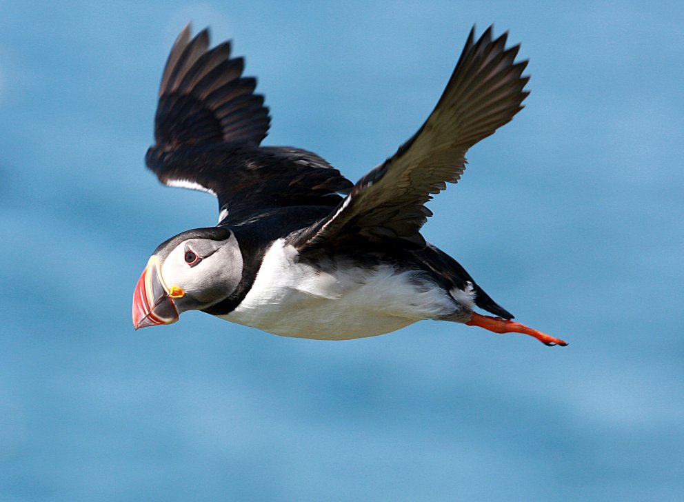
Grímsey is one of the best places on Iceland’s coast to watch cliff-nesting birds. These seabirds generally arrive in March for the breeding season and depart by August. Icelanders traditionally went “climming,” descending birdcliffs on ropes to gather eggs, and this practice continues on Grímsey. In the scree beneath the cliffs is one of Iceland’s biggest Razorbill colonies. Grímsey also boasts the largest Puffin colony on the north coast of Iceland. The Puffin stays on the island from late April until early August, and is easily approachable. Grímsey also has one of Iceland’s largest and densest Arctic Tern colonies.
Siglufjörður
Siglufjörður is surrounded by high mountains, with little lowland between the mountains and the sea. Man lives there in close community with nature, and a diverse range of birdlife is within easy reach of the village. At the head of the fjord, inland from the harbour, extensive mudflats have formed where the Hólsá river flows out into the sea, creating ideal conditions for waders and coastal birds.
By the road at the west side of the fjord is an information sign about the main bird species in the area. The best way to watch birds is to walk along the gravel track on the east side of the fjord, or the old disused runway nearby – which stretches about a km along the head of the fjord on the east side, from the Hólsá estuary. Parking is available at the churchyard a little farther up (by road no. 76).
Along by the old runway is a more-or-less continuous colony of Arctic Terns and Eiders. In addition most of the common species of coastal and heathland birds may be seen, especially in spring and early summer.
Ólafsfjörður and the lakes Ólafsfjarðarvatn & Þóroddsstaðartjörn
Ólafsfjörður is surrounded by mountains that slope steeply down to the sea. At the head of the fjord is a broad grassy valley with Ólafsfjarðarvatn (Ólafsfjörður Lake). The natural environment is characterized by a special interplay of land and sea. Ólafsfjörður Lake is an unusual natural phenomenon, as at high tide seawater flows into the lake. As the specific gravity of salt water is greater than that of fresh water, the bottom of the lake is salty while the upper layers are fresh water. The fish species in the lake thus include both saltwater fish such as Cod, Herring and Plaice and freshwater species such as Trout and Arctic Char.
During the summer (May-September) a hide is located at Þóroddsstaðatjörn (Þóroddsstaðir Pond) at the end of Ólafsfjörður Lake, about 4.5 km inland from the village. A gravel road (no. 802) leads along the western side of the lake, where the hide is about 30 m from the road. There is no car park as such, but visitors can park at the side of the road.
Birdlife abounds around Ólafsfjörður Lake: seabirds and gulls at the seaward end, and ducks and waders in the surrounding wetlands. Slavonian Grebes nest close to the village, and the Great Northern Diver is seen every year on the lake. On good days in spring and summer, Þóroddsstaðir Pond offers the opportunity to see a wide variety of waterfowl, waders and passerine species; the Red-throated Diver also nests nearby.
Svarfaðardalur by Dalvík, the headland Hrísahöfði
Svarfaðardalur is verdant and surrounded by high mountains. The lower part of the valley has extensive wetlands which abound in birdlife: the Svarfaðardalur Nature Reserve, the first wetland area granted protection in Iceland extends over an area of 8 km².
Here the birdwatcher can easily observe an unusually large variety of bird species in a small area – mainly waterfowl and waders, but also passerines and gulls. Around 30-40 bird species breed in the Nature Reserve, and others pass through. The lower birdwatching area close to Dalvík comprises wetland from the sea and along the Svarfaðardalsá river below road 82. The area of the Hrísahöfði headland and Hrísatjörn pond abounds in birdlife, and provides good conditions for birdwatchers.
An entrance sign is located at the Olís petrol station at Dalvík, where parking is also available. A footpath leads along the Svarfaðardalsá river, crossing a bridge at Árgerði to Hrísahöfði, and along the banks of Hrísatjörn. Along the path are information signs about vegetation and birdlife, as well as geology and historical sites. From the Árgerði bridge it is also possible to follow a marked walking route along the river to Húsabakki, 4.5 km away.
The Great Northern Diver is seen every year on the pond, and the Red-throated Diver nests nearby and can often be spotted on the river from the road. The Slavonian Grebe is also noticeable, and the Whooper Swan breeds here every year. The Black-headed Gull nests densely by Dalvík, and the Common Gull population is rising. At the east of Hrísatjörn is a hide.
Svarfaðardalur by Dalvík, and the area of Húsabakki
The birdwatching area at Húsabakki is at the inland end of the Svarfaðardalur Nature Reserve, about 5 km from Dalvík (Svarfaðardalsvegur no. 805). This includes wetland and meadow/scrub by Tjarnartjörn (Tjörn Pond) and along the banks of the Svarfaðardalsá. Húsabakki, formerly a school, is now a community centre and hotel.
At Húsabakki is an entrance sign for the Nature Reserve, and parking facilities. A marked walking route with information signs leads past the hide at Tjarnartjörn down to the river. The path then follows the riverbank through scrub and marshland back to Húsabakki.
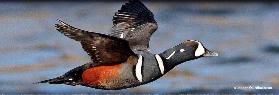
From the path a wide variety of waterfowl and waders may be seen; also Ptarmigan and passerines. Black-tailed Godwit, Whimbrel and Greylag Geese are abundant, and Harlequin Ducks are often seen on fast-flowing reaches of the river.
Hrísey island
Hrísey island, sometimes called “the Perl of Eyjafjörður,” is the second-largest island off Iceland’s coast, with an area of 7.4 km². From Árskógssandur (road no. 808) a ferry sails to the island every two hours daily. The crossing takes 15 minutes.
Three clearly-marked circular routes of 2.3, 4.5 and 5 km lie through the village and the southern part of the island, where the birdlife is most diverse.
Along the paths are information signs about vegetation, birdlife and other items of interest.
At Lambhagatjörn (Lambhagi Pond), north of the village and less than a km from the harbour, is a hide. Nearly 40 bird species breed on the island, and are densely spaced during the nesting season. The Ptarmigan has a special place among the island’s birds, and features on the community’s official crest. It is a protected species on Hrísey, although it is hunted elsewhere in the country; research has been carried out on the birds for many years. Many Arctic Terns nest on Hrísey, and waders also form dense breeding colonies. The birds benefit from the absence of any wild predators on the island. One of Iceland’s largest colonies of Common Gull is on Hrísey. At the north of the island is an Eider colony which is protected and utilised by the landowners. Access is by permission only.
Krossanesborgir by Akureyri
Krossanesborgir is a nature reserve just north of Akureyri, about 1 km² in area. Moulded by glacial action during the Ice Age, the area is characterised by low rounded rocks with glacial striations, known as whalebacks, interspersed with marshland.
Parking is available at the south of the area, which is reached from Óðinsnes (street name). An entrance sign provides information on birds, vegetation and walking routes. Gravel footpaths lead from the car park through the rock formation, providing options for routes of different lengths.
Along the paths are signs providing information about history, geology, vegetation and birdlife. At Djáknatjörn pond, in the north of Krossanesborgir, about 1.3 km from the car park, is a hide.
About 30 bird species breed in the area, totalling 5-600 pairs. These include a big gull colony and a large number of Ptarmigan. In addition many species of waders, waterfowl and passerines breed here.
Naustaborgir by Akureyri
Naustaborgir is a cluster of tall rocky formations north of the campsite at Hamrar. To the west is grassy marshland, and the Hundatjörn pond, which was drained in the 1940s, but reclaimed in 2007 by damming.
A path about 3 km long leads through the area from the Naustahverfi district of Akureyri, south of the Jaðar golf course. At the end of Ljómatún (street name) parking is available. A hide is located about 1 km from there.
Waders, Black-headed Gulls and ducks nest at Hundatjörn, while passerines nest in the varied woodland around it, including such species as Redwing, Redpoll, Wren and Goldcrest – a recent arrival and the smallest Icelandic bird.
Óshólmar delta by Akureyri
Deltas are relatively few in Iceland, and almost all are in the north. The largest is the Eyjafjarðará river delta. The area forms the low point of 20 km of lowland along the river banks, formed by fluvial sedimentation since the end of the Ice Age. The lowest part of the area comprises extensive mudflats which are exposed at low tide, providing a feast for numerous bird species. The Ring Road (no. 1) crosses Eyjafjörður at the mudflats (Leiran). While the delta and mudflats have suffered encroachment by transport infrastructure in recent years (such as airport and road construction), they remain one of Iceland’s most important habitats for thousands of wetland birds which migrate there every year.
The old road across the delta, now closed to motor traffic, is a popular route with joggers and walkers. An entrance sign is located on Eyjafjarðarbraut vestri (no. 821) at the south of the airport. From there it is possible to walk to a hide at Stóri-Eyrarlandshólmi (2.5 km), or cross the three old bridges over the Eyjafjarðará river (3.5 km) to Eyjafjarðarbraut eystri (no. 829) on the eastern side of the fjord.
The Leiruvegur road (no. 1) and Eyjafjarðarbraut eystri (no. 829) provide good views over the Leiran mudflats. Cars can be parked in lay-bys along Eyjafjarðarbraut eystri (no. 829).
30-40 bird species breed in the area, and others pass through. The Black-headed Gull and Eider are the commonest species, followed by the Arctic Tern, Greylag Goose, and various waders and ducks.
Kristnes Pond
Kristnestjörn (Kristnes Pond) lies just below the farmstead of Kristnes by Eyjafjarðarbraut vestri (no. 821). The pond has abundant vegetation and around it is sedge-marsh, providing an ideal habitat for waterfowl.
Above the pond and marsh is a hide, a 500m walk along the old road from the southern end of Kristnesvegur (no. 822).
A pair of Whooper Swans nest at the pond, where the Slavonian Grebe may also be seen, along with a variety of ducks and waders. In April-May large numbers of Wigeon call here, 100-300 birds.
Svalbarðseyri & the pond Tungutjörn
Svalbarðseyri is a small fishing village on the east of Eyjafjörður about 15 km from Akureyri. Turn off the Ring Road (no.1) onto the Svalbarðseyri road (no. 830), and drive down to the lighthouse at the top of the beach. At the shore are two ponds, which are surrounded by abundant birdlife – especial the more northerly, Tungutjörn, which has more vegetation.
Parking is available at the lighthouse. A gravel road leads along the shore, passing by both ponds. A recommended walk is along the shore from the lighthouse past Tungutjörn and back again, about
1 km.
At the ponds on the shore of the mudflats south of Tungutjörn all the main species of Icelandic waders may be seen, along with gulls, Slavonian Grebe, Eider, Long-tailed Duck and other ducks. Various passage migrants are also seen here in May-June, such as the Turnstone and Knot, on their way to more northerly breeding grounds.
Svalbarðseyri is one of the best locations in Eyjafjörður for spotting and watching such visitors.