Similar to its ancient predecessor, Stonehenge, the Arctic Henge is like a huge sundial, aiming to capture the sunrays, cast shadows in precise locations and capture the light between aligned gateways.
Shortcuts
Raufarhöfn is the northernmost town on the Icelandic mainland, nestled on the eastern shore of Melrakkaslétta peninsula. Named after its natural harbor, Raufarhöfn was used for shipping from early on as mentioned in the sagas. It became an authorized trading post in 1833 but the village started forming after 1875.
Herring fishery was a pivotal factor in the growth of the village in the early 20th century and by 1944 Raufarhöfn was the second-largest herring station in Iceland. The local population reached 500 in the latter part of the century but during the height of the herring bonanza, there could also be over 2000 migrant workers here at times.
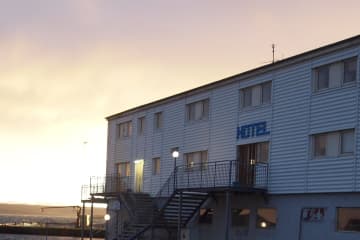
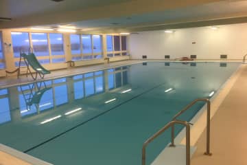
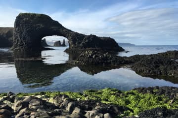
Raufarhöfn is now a quiet little fishing village in the process of redefining itself. All basic services can be found in Raufarhöfn and this Arctic Circle village is a peaceful setting to enjoy walks, fishing or birdwatching, and offers a front-row seat for enjoying the midnight sun in summer and northern lights in winter.
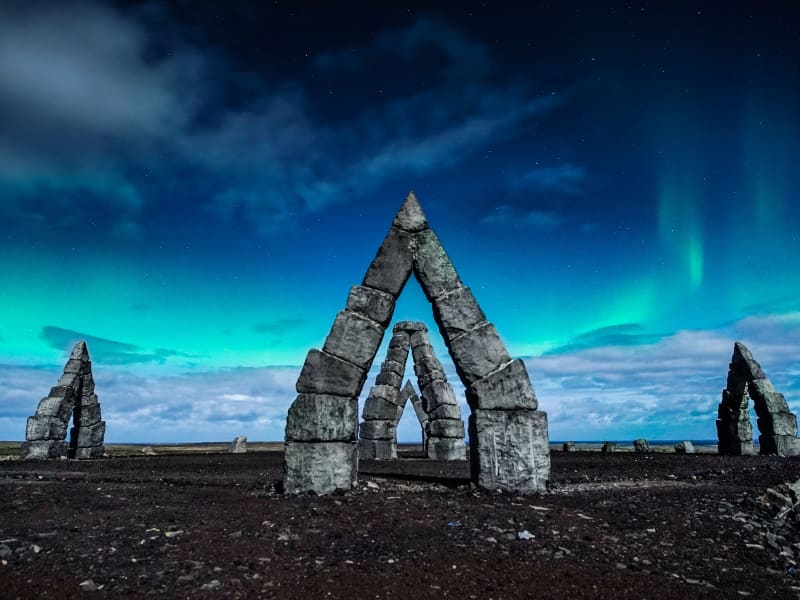
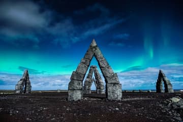
On a small elevation at the edge of the village, the Arctic Henge is being constructed. A huge stone sundial with allusions to mythology and folklore, designed to interact with the unique natural light in this village at the edge of the arctic.

675,676
Highlights in Raufarhöfn
Travel directory for Raufarhöfn
The official travel index of Iceland
Museums
N.-Þingeyjarsýsla Folk Museum
Museums
Húsavík Whale Museum
Restaurants
Exhibitions
The Earth Quake Center
Bird Watching
Gentle Giants Whale Watching
Boat Tours
Salka Whale Watching
Swimming Pools
Raufarhöfn Swimming pool
Geothermal baths
Travel Agency
North Sailing Whale Watching
Swimming Pools
Húsavík Swimming pool
Day Tours
Húsavík Adventures
Guesthouses
Dettifoss Guesthouse
Museums
Húsavík Museum
Camping
Ásbyrgi Visitor Centre, Ásbyrgi
Travel Agency
Scandinavia Travel North
Cottages
Nordic Natura
Winter adventure
Húsavík Ski Area
Others
- 465-1233
- Baughóll 31c
- 640 Húsavík
- 895-1776
- Hafnarbraut 2
- 675 Raufarhöfn
- 868-9771, 696-5942
- Katlavellir
- 640 Húsavík
- 464-1000
- Kaldbakur
- 640 Húsavík
- 892-1744, 862-1504, 862-1504
- Álfasteinn
- 650 Laugar
- 6505252
- Garðarsbraut 79
- 640 Húsavík
- 898-9853
- Hvirfilvellir
- 671 Kópasker
- 860-4919
Camping
Raufarhöfn Camping Ground
Guesthouses
Dettifoss Guesthouse
Hostels
Kópasker HI Hostel
Hotels
Hotel Norðurljós
Camping
Kópasker Camping Ground
Guesthouses
Skjálfandi apartments
Guesthouses
Húsavík Guesthouse
Guesthouses
Melar Guesthouse
Camping
Húsavík Camping Ground
Cottages
Nordic Natura
Guesthouses
Guesthouse Árból
Guesthouses
Nest Guesthouse
Camping
Ásbyrgi Visitor Centre, Ásbyrgi
Guesthouses
Garður Guesthouse
Guesthouses
Sólsetur Guesthouse
Hotels
Fosshotel Husavík
Hotels
Husavik Cape Hotel
Others
- Vesturdalur Jökulsárgljúfrum
- 671 Kópasker
- 470-7100
- Túngata 13
- 640 Húsavík
- 866-3645, 464-0200
- Vallholtsvegur 9
- 640 Húsavík
- 8660882
- Kaldbakur
- 640 Húsavík
- 892-1744, 862-1504, 862-1504
- Árdalur
- 671 Kópasker
- 659-2282, 465-2282
- Þeistareykir
- 640 Húsavík
- 866 4083, 464-3510
- Héðinsbraut 11
- 640 Húsavík
- 852-0010
- Keldunes II
- 671 Kópasker
- 465-2275, 861-2275
- Hof
- 640 Húsavík
- 894-0872
Travel Agency
North Sailing Whale Watching
Restaurants
Veitingahúsið Salka
Restaurants
Hotels
Fosshotel Husavík
Camping
Ásbyrgi Visitor Centre, Ásbyrgi
Cafés
Restaurants
Hotels
Hotel Norðurljós
Others
- Garðarsbraut 64
- 640 Húsavík
- 464-1040
- Árdalur
- 671 Kópasker
- 659-2282, 465-2282
- Héðinsbraut 4
- 640 Húsavík
- 789-0808
- Kelduhverfi
- 671 Kópasker
- 465-2260, 849-0753
- Héðinsbraut 2
- 640 Húsavík
- 464-2650
- Bakkagata 10
- 670 Kópasker
- 465-1150
Nature
Ásbyrgi canyon
Ásbyrgi is one of the wonders of nature, a well forested horse-shoe shaped canyon in Oxarfjordur. Asbyrgi is a part of Jökulsárgljúfur canyon, within the Vatnajökull National Park. The Jökulsárgljúfur site of the National park reaches from highway 85, by Ásbyrgi south to Dettifoss, covering an area of 120 km2. Informative visitor's centre, shop, golf course and camping site are located by Ásbyrgi.
Many hiking tracks are in the vicinity of Ásbyrgi. Ásbyrgi canyon is part of the Diamond Circle explore the Diamond Circle https://www.northiceland.is/diamondcircle.
Nature
Dettifoss Waterfall
The Dettifoss waterfall is the most powerful waterfall in Europe, 500 cubic meters of water per second plunge over the edge. Dettifoss is 45 m high and 100m wide. A nice hiking trail, 34km, goes along the canyon from Dettifoss to Asbyrgi. Camping is possible in Vesturdalur.
Road 864 goes from road 85 past Dettifoss on the east side towards road 1. This is a gravel road and driving speed depends on road conditions each time. Road 864 is closed during wintertime due to snow or wet conditions (muddy road) and does not open until early summer (end of May).
For the biggest part of it, road 862 on the west side of Dettifoss has been paved but the construction of the road is still ongoing and will be finished in the summer of 2020. The parts that have not been completed are gravel. From May-September, the road is passable for normal vehicles from Asbyrgi to Dettifoss, with Vesturdalur (Hljodaklettar) and Holmatungur between. The conditions of gravel roads in Iceland can vary, so travelers are asked to be aware of road conditions at any time and adjust the driving speed to the conditions.
Road 862 is closed during wintertime, due to snow or wet conditions (muddy road) and does not open until late May or early June. This paved part of the road that goes from Dettifoss and to road no. 1 is not in service from January until the beginning of April. Dettifoss Waterfall is part of the Diamond Circle explore the Diamond Circle https://www.northiceland.is/diamondcircle.
Nature
Melrakkasletta peninsula
The "Sléttan", as the Melrakkaslétta is often called, is the
peninsula reaching from Kópasker in the west to Raufarhöfn in
the east. The coastline is indented with creeks and lagoons
and has grassy heathlands and dozens of lakes teeming with
fish. This area offers shelter and is a temporary stopping
place for thousands and thousands of birds that come here for
the summer or rest here for their further flights to the north
or to the south. Seals can also be seen resting on skerries
and whales are spotted off the coast as well as foxes and mink
on the heaths close to rivers and lakes.
The richly varied vegetation has few parallels. No one place attracts the traveller more than some other place. Nature in its entirety
does. A veritable mecca for lowers of nature. This is infact
one of the best places in Iceland to see the midnight sun and
from late August to April the famous northern lights.
History and Culture
The Þingeyjarsýsla District Museum
Byggðasafn S-Þing (The South Þingeyjarsýsla District Museum) is housed within the Safnahúsið at Húsavík and is to be found on the middle floor of the building. This exhibition is called "100 years of Life and Nature in Þingeyjarsýsla" and attempts to shed light on the interaction of man and nature. It is, therefore partly a natural history exhibition.
Opening times:
Summer: 1 June-31 August, daily 10:00-18:00.
Winter: 1 September-31 May, weekdays 10:00-16:00.
Nature
Hraunahafnartangi
Hraunhafnartangi and Rifstangi are the northernmost points of Iceland, at the edge of the arctic circle. Hraunhafnartangi derives its name from the natural harbor which is mentioned in 13th century literature. Þorgeirsdys, a stone mound found on Hraunhafnartangi, is believed the burial mound of Þorgeir Hávarsson who was slain there in an epic 11th century battle chronicled in Fóstbræðrasaga.
Visitors who bring pictures of themselves by Hraunhafnartangi lighthouse can receive a certificate from local service providers of having been to the northernmost point of the Icelandic mainland.
Nature
Arctic Henge
Set in Raufarhöfn, one of the most remote and northernmost villages in Iceland where the Arctic Circle lies just off the coast, the Arctic Henge (Heimskautsgerðið) is under construction. Similar to its ancient predecessor, Stonehenge, the Arctic Henge is like a huge sundial, aiming to capture the sunrays, cast shadows in precise locations and capture the light between aligned gateways.
History
Heimskautsgerðið (The Arctic-Henge) has it s roots in the innovators Erlingur Thoroddsen's speculations about the possibility to use endless vistas, where nothing obstructs the horizon, and the midnight sun. The idea to use the dwarf names from the eddic poem Völuspá (Prophecy of the Seeress) and modernize some aspects of the old world of the Sagas, soon became a part of these speculations. The first version of the idea is from 1998 but in 2004 it was finalized, with allusions to mythology and folklore, designed to interact with the unique natural light. The designer of the project is Haukur Halldórsson.
No one has been able to explain the dwarfs in the Völuspá, apart from Austri (East), Vestri (West), Norðri (North) and Suðri (South), who carry the sky. By connecting the names of the dwarfs to the season, as for example Bjartur (Bright) Blíður (Sweet) and Svásuður (Gengle) to the summer, it is possible to fit the names of the dwarfs to a yearly circle of 72 weeks. The year-circle of the dwarfs becomes a kind of almanac, where each dwarf controls a five day period. All the dwarfs have been given a role and they have all have their own personalities. This means that the dwarfs can be connected to birthdays and people can connect to their personal dwarf.
Around this made up world rises the Heimskautsgerði (Arctic-Henge) on the Melrakkaás (Foxhill) in Raufarhöfn. The Heimskautsgerði is around 50 meters in diameter, with 6 meter high gates that face the main directions. Between the gates is a high wall with a small opening at the top. Inside the circle stands 10 meter high column on four pillars. The column will be topped with cut prism-glass that splits up the sunlight unto the primary colors. The opening between the pillar look towards the main directions, so example the midnight sun can be seen from the south gate through the middle column and the north gate. The play of light and shadow will follow the time of the day. The openings on the wall will let in the sunrays so when the building is completed a sundial can be set up.
Inside the circle are 68 dwarfs who stand around a circular dwarf trail. Inside the trail is the polar star pointer, and does exactly what its name says. There you can also find the throne of the sun that is meant to be a place where the traveler can sit down to have his picture taken. Also a hall of rays, which is a sort of sanctuary between high columns, with one seat, where the guest can empty his mind an renew his energy. An altar of fire and water, reminds us of the power of the elements, where events can be performed, for example weddings, oath-taking and so forth.
More information available at www.arctichenge.com
Getting There
It´s about 130 km from Húsavík, but good roads all the way, so allow 1.5 hrs.
Follow the road 85 northeast out of Húsavík, past Ásbyrgi, taking the 874 road junction east just before Kópasker. Once in Raufarhöfn, you can´t miss the stones, looming impressively on the hill above the town. There is a short track to drive up, or you can walk if you prefer. Here is the route.
Nature
Jokulsargljufur
This dramatic canyon, Jökulsárgljúfur, was formed by the actions of water, fire and ice. Enormous, catastrophic glacial bursts are believed to have carved out the deep ravines and rocky basins, the most famous of which is Ásbyrgi.
The Hljóðaklettar outcrops are the cores of ancient volcanoes, revealed when the river swept away all the loose volcanic material.
The waterfalls on the River Jökulsá á Fjöllum, Selfoss, Dettifoss, Hafragilsfoss and Réttarfoss are powerful and impressive.
The Hólmatungur district is an area of contrasts: crystal clear streams and bubbling brooks cross the land before emptying into the raging, chocolate-coloured torrent. A delicate balance of flora and fauna thrives under the protection of cliffs and scree slopes.