Holuhraun Revisited
Words by Vala Hafstad
Photos by Páll Stefánsson
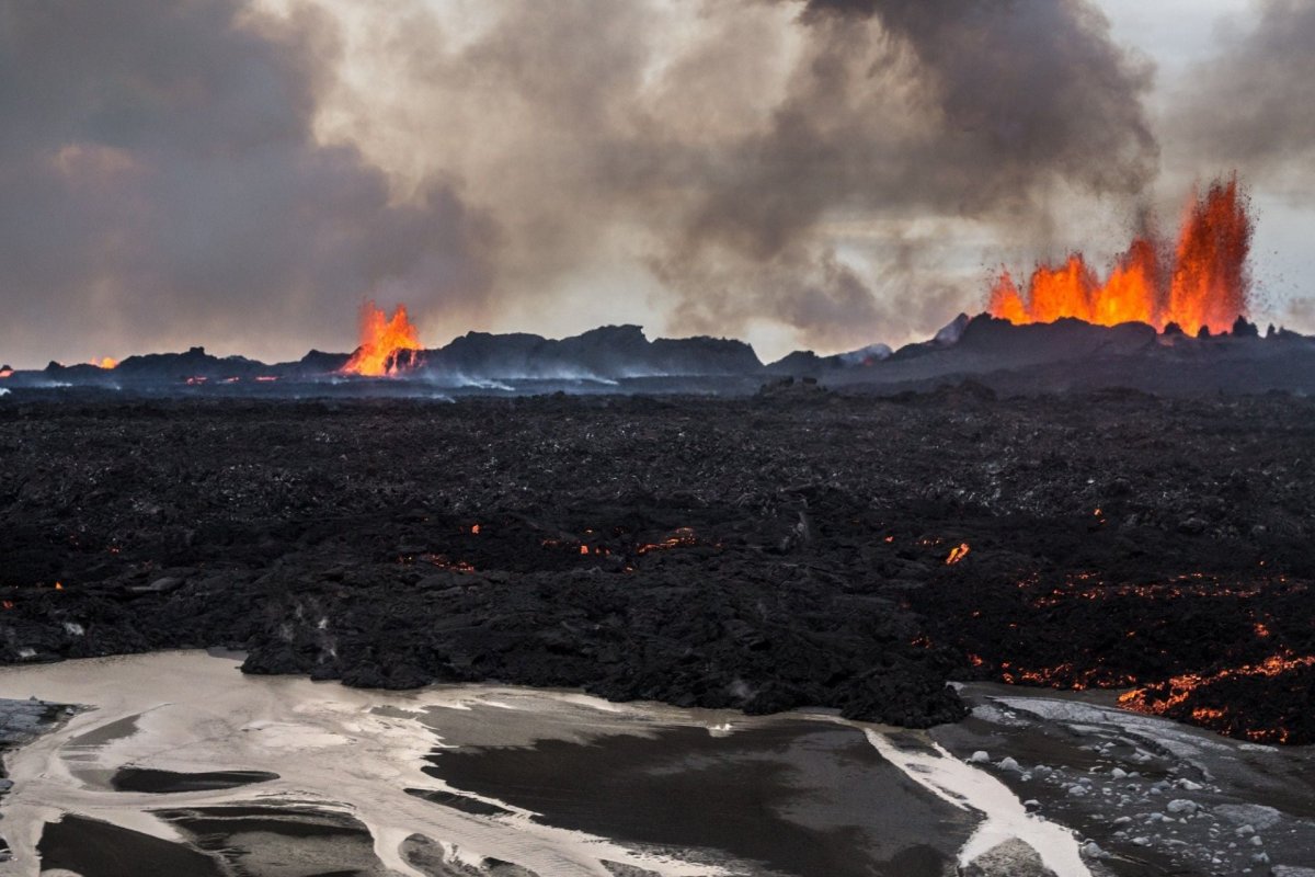
Almost half a year has gone by since the Holuhraun eruption came to and end. The train of events began on August 16, 2014, with the violent shaking of Bárðarbunga, Iceland’s biggest volcano, located under Vatnajökull glacier in the country’s southeast, giving us notice that it would not be able to take the pressure much longer. The question was where Mother Nature would vent its anger. Gradually, the series of earthquakes moved to the northeast, up to 70 km (44 miles) from Bárðarbunga and beyond the edge of Vatnajökull. Finally, on August 29, a fissure eruption began in Holuhraun, a lava field 50 kilometers (31 miles) north of Bárðarbunga. The eruption lasted until February 27 this year—for six months. Red, hot magma flowed from a 1.6-kilometer (1-mile) long fissure, spreading over the old Holuhraun lava field.
When Mother Nature finally calmed down, the lava had spread over 84 square kilometers (32 square miles), making the lava field almost equal in size to the island of Manhattan. At that point, nearly 12 million tons of sulfur dioxide (SO2) had been spewed—more than the total emission of dangerous gases in all of Europe in 2011. Luckily, the eruption took place in a remote area, minimizing its impact on the population.
Approach Slowly.
Gradually, tourists are gaining access to the area, which to begin with was closed to all but scientists and those with special permission, such as journalists and photographers. At the beginning of July, employees of Vatnajökull National Park opened two hiking trails in the lava field, the longer of which lies from the road across Dyngjusandur plains and into Holuhraun from the northern side, close to the center of the edge of the lava field. The other one is farther to the east, accessible from the road toward Svartá river. The trails take you across very rough lava and require steady feet. Good hiking boots are recommended.
The longer hiking trail is 800 meters (0.5 miles) long, close to the center of the northern side of the lava field, and lies in a circle. Jóhanna Katrín Þórhallsdóttir, a highland representative at the Vatnajökull National Park, says this trail offers a beautiful view of the area. The other trail is shorter, close to 200 meters, (220 yards) on the eastern edge of Holuhraun. This trail, she says, has been immensely popular with tourists this summer, not least because of the natural hot spring that has formed in the lava field, allowing tourists to enjoy the heat of the moment by bathing. The hot spring was formed as rainwater, mixed with glacial melt-water, flowed from under the lava. Jóhanna explains that two fairly hot creeks must be waded through before reaching the comfortably warm spring.
Guided tours along the trails were offered twice a day by park rangers in the middle of summer, but this late in the season, no guided tours are scheduled, unless specially requested. The westernmost part of the lava field, closer to the crater, is warmer and closed to the public, both because harmful gases are still being emitted and because the warmer lava is unstable. As it cools down, it subsides. As long as the lava is on the move, tourists must be prevented from moving about it, Jóhanna emphasizes. A great view of the crater, however, can still be enjoyed from a distance.
Information on hiking trail maps.
These are the experts to take you to the new bathing spot, Holuhraun.